4+ hours endurance and 100+ miles data link or unlimited signal range with Starlink.
Advanced Sensor Suite
Thermal, LiDAR, Multispectral, Oblique, High Resolution RGB, Gimbaled
Safety Protocols for BVLOS Compliance
Dual GPS and Compass, ADS-B obstacle avoidance, Emergency procedure response with auto return and land function.
Industries
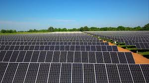
Whether you’re inspecting oil pipelines, monitoring solar farm panels, or coordinating a search and rescue mission, our drone solutions bring you the data and visibility you need—without risking human lives or blowing your budget. Here’s how we cater to specific industries:
Rapid Deployment: Launch within Minutes, ideal for disaster zones or remote terrain.
Thermal Imaging: Locate missing persons or survivors quickly.
Safer: Built in Obstacle and traffic avoidance won't get distracted in congested airspace.
Infrared & Multispectral Sensors: Assess forest health or spot and track wildlife.
Detailed Mapping: 3D terrain mapping to track deforestation or plan reforestation efforts.
Quality – We are committed to delivering top-notch services that exceed industry standards.
Efficiency – Our BVLOS solutions can get the job done faster, cheaper and safer than conventional helicopters.
Reliability – With a dedicated network of support personnel, advanced flight and mapping software and AI interpreted data points, we ensure timely deliverables and dependable service.
Innovation – We continually strive to improve our operations through technological advancements, positioning us as pioneers in the industry.
Customer Relationships – Building strong, long-lasting relationships with our clients and partners is at the heart of our business.